
Plik:World map of countries by ecological footprint (2007).svg

Wielkość pliku podglądu PNG dla pliku SVG: 800 × 353 pikseli Inne rozdzielczości: 320 × 141 pikseli | 640 × 283 pikseli | 1024 × 452 pikseli | 1280 × 565 pikseli | 2560 × 1130 pikseli | 940 × 415 pikseli.
Rozmiar pierwotny (Plik SVG, nominalnie 940 × 415 pikseli, rozmiar pliku: 1,36 MB)
Opis
| Opis |
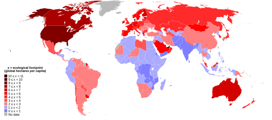
English: World map of countries shaded according to their ecological footprint in 2007 (published on 13 October 2010 by the Global Footprint Network). It is measured by the amount of global hectares that are affected by humans per capita of the country. Lighter shades denote countries with a lower ecological footprint per capita and darker shaded for countries with a higher ecological footprint per capita. The total ecological footprint (global hectares affected by humans) is measured as a total of six factors: cropland footprint, grazing footprint, forest footprint, fishing ground footprint, carbon footprint and built-up land.
Français : Mapemonde colorée selon l'empreinte écologique moyenne des habitants de chaque pays, exprimée en ha par personne, en 2007. Le tons plus chairs correspondent à une empreinte faible, les tons plus sombres à une empreinte plus forte. Six facteurs sont pris en compte pour mesurer cette empreinte: L'agriculture, le pâturage, l'exploitation forestière, la pêche, la production de carbone et l'urbanisation.
No data
0 ≤ x < 1
1 ≤ x < 2
2 ≤ x < 3
3 ≤ x < 4
4 ≤ x < 5
5 ≤ x < 6
6 ≤ x < 1
7 ≤ x < 8
8 ≤ x < 9
9 ≤ x < 10
10 ≤ x < 11 |
| Data | |
| Źródło | Self-made with data from list of countries by ecological footprint. |
| Autor | Jolly Janner |
| Inne wersje |
|


.svg)
Licencja
| Ja, właściciel praw autorskich do tej pracy, udostępniam ją jako własność publiczną. Dotyczy to całego świata. W niektórych krajach może nie być to prawnie możliwe, jeśli tak, to: Zapewniam każdemu prawo do użycia tej pracy w dowolnym celu, bez żadnych ograniczeń, chyba że te ograniczenia są wymagane przez prawo. |
Historia pliku
Kliknij na datę/czas, aby zobaczyć, jak plik wyglądał w tym czasie.
| Data i czas | Miniatura | Wymiary | Użytkownik | Opis | |
|---|---|---|---|---|---|
| aktualny | 03:24, 30 mar 2018 | | 940 × 415 (1,36 MB) | Sisgeo | Employ a different color for countries under 2.1 gHa, the estimated limit of sustainability. |
| 20:44, 29 paź 2010 |  | 940 × 415 (1,68 MB) | Jolly Janner | Added a white box to represent the background | |
| 20:38, 29 paź 2010 |  | 940 × 415 (1,68 MB) | Jolly Janner | white background | |
| 20:36, 29 paź 2010 |  | 940 × 415 (1,68 MB) | Jolly Janner | white background | |
| 20:24, 29 paź 2010 |  | 940 × 415 (1,68 MB) | Jolly Janner | == {{int:filedesc}} == {{Information |Description={{en|1=World map of countries shaded according to their ecological footprint in 2007 (published on 13 October 2010 by the Global Footprint Network). It is measured by the amoun |
Lokalne wykorzystanie pliku
Poniższa strona korzysta z tego pliku:
Globalne wykorzystanie pliku
Ten plik jest wykorzystywany także w innych projektach wiki:
- Wykorzystanie na ca.wikipedia.org
- Wykorzystanie na el.wikipedia.org
- Wykorzystanie na en.wikipedia.org
- Wykorzystanie na en.wikibooks.org
- Wykorzystanie na eu.wikipedia.org
- Wykorzystanie na fa.wikipedia.org
- Wykorzystanie na fr.wikipedia.org
- Wykorzystanie na gl.wikipedia.org
- Wykorzystanie na hi.wikipedia.org
- Wykorzystanie na it.wikipedia.org
- Wykorzystanie na ms.wikipedia.org
- Wykorzystanie na nl.wikipedia.org
- Wykorzystanie na pl.wikipedia.org
- Wykorzystanie na ro.wikipedia.org
- Wykorzystanie na sk.wikipedia.org
- Wykorzystanie na sr.wikipedia.org
- Wykorzystanie na ta.wikipedia.org
- Wykorzystanie na uk.wikipedia.org
- Wykorzystanie na zh.wikipedia.org
.svg)